Introduction
Hamrin oil field is
one of the important oil fields in northern Iraq. The field represent an asymmetrical
anticline that extend NW-SE for more than 101 km, with width (4-7 km) width (Figure 1) [1]. Hamrin oil field located
at the south western boundary of the foot hill zone of the unstable shelf area
according to the tectonic division of Iraq [2]. The foot hill zone is gently
folded during the Pliocene age and is characterized by wider shallow syncline [3].
The foothill zone has the deepest precambrian basement in Iraq (≈13 km) and
very thick Miocene-Pliocene molasses sediments (3 km thick) [2]. The zone
comprises two longitudinal unites, the Makhul-Hamrin
subzone in SW and Butmah-Chemchemal subzone in the NE [4].
The tertiary reservoir in Hamrin represented by two main formations, Jeribe and
Euphrates formation and one secondary is Dhiban formation. These formations
belong to latest Eocene-Recent Megasequence, AP11 of the tectonic history of
Iraq, this mega sequence is associated with the closure of Neo-Tethyan basin
along N and E sides of the Arabian plate, and opening of the Gulf of Aden and
Red sea on the S and W of the plate [2]. The two main elements of the petroleum
system of this area, the reservoir units represented by Jeribe, Euphrates formations
and the cap rock that sealing the reservoirs units represented by Fatha formation
were deposited during this mega sequence.
The determination of rock petro physical properties
is needed during the reservoir characterization process because it affects the estimation
of reserves (porosity and saturation) and well deliverability (permeability) as
well as to determine the ability of borehole to produce hydrocarbon [5,6]. As
the petro physical properties are controlled by depositional environment, diagenesis,
tectonic process and the depositional environment of the reservoir units of the
hydrocarbon
bearing formations in Hamrin oil field will show vertical
and lateral variation of its petro physical properties across the field. The
best knowledge of these variation of the petro physical properties, laterally
and vertically will be necessary to choose the best location for the drilled
wells in the future and the best interval for perforation during the
development of the oil fields.
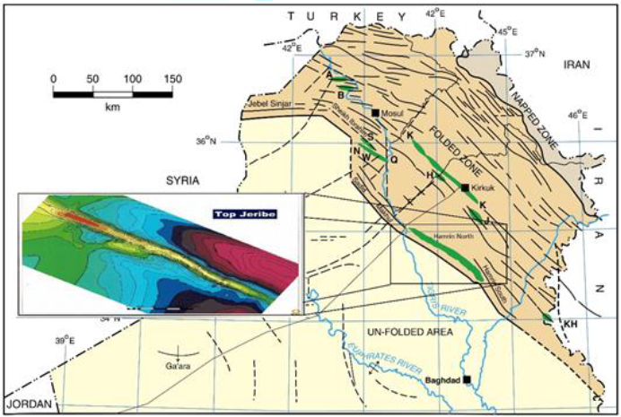
Figure1:Location map of the study area.
Material
and Method
Computer
Processed Interpretation (CPI) was performed using Interactive
Petrophysics (IP) software version 3.5 for log interpretation to estimate the
petro physical properties of Jeribe, Euphrates and Dhiban formations. Depending
on well log data, Gama Ray log (GR), tool that detects the natural
radioactivity of the rocks, The Density Log (RHOB), tool that determine the
density of rocks, Neutron Log (NPHI), to calculate the porosity, Sonic Log (Δt)
to measure the transient time for sonic waves that travel through the
formation, and resistivity log to determine the resistivity of the formation
that reflect the type of fluids (water, hydrocarbon) trapped in these
formations. Seven wells (Hr-54, Hr-58, Hr-63, Hr-59, Hr-69, Hr-56, and Hr-66)
in Hamrin oil field were selected to conduct the study.
Formation
Evaluation
Formation evaluation is the application of
scientific principles, engineering concepts and technological innovation in
exploration and prospecting hydrocarbon resources in the geological formation.
It plays critical role in resources assessment and is important in selection
the best locations for wells as well as the best interval for perforation during
the development phase of the oil fields [7]. It involves detailed and
systematic data acquisition, gathering, analysis and interpretation, both
quantitatively and qualitatively while applying engineering and scientific
principles.
Tertiary
Reservoir in Hamrin Oil Field
The main tertiary reservoirs in Hamrin oil field are
Jeribe and
Euphrates formations, and the secondary reservoir is Dhiban formation
(Figure 2).
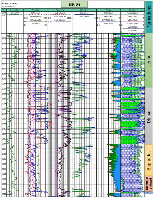
Figure2:Computer processed interpretation for Jeribe, Dhiban and Euphrates formations in Hamrin oil field.
The studied formations belong to a group of
carbonate reservoirs which houses much of Iraq's proven reserves. Jeribe formation
is an attractive petroleum completion target in most of the northern oil field
of Iraq. The formation was first mentioned by Damesin in 1936, but was first
defined by Bellen in 1957. The formation represents the basinal, transgressive
limestone dominated part of the Middle Miocene sub-cycle [3]. The thickness of
Jeribe formation in Hamrin area is about 50 m. The formation was deposited in
lagoon (back reef) and reef environment, with sign of more off shore facies. There
are in fact three main facies, which interfinger extensively with each other.
These are a lagoon facies, reef facies and detrital facies that were probably
deposited in front of a reef in shallow quiet sea, a gulf or an extended sea
arm. The Euphrates formation (lower Miocene) was first described by De Becockh
and Viennot in 1929 [8]. Where the type section was near valley Fuhaimi near
Anah city west Iraq, the formation is consist of three unites from bottom to
top:
Unit A, cavernous and conglomeratic limestone, unit
B, shelly limestone and unit C, marly and chalky limestone, most of studies
reported that Euphrates formation was deposited in shallow marine environments
and lagoonal environments isolated by an organic barrier [8]. Dhiban Formation
was defined by Henson in 1940, and amended by Bellen in 1957 [8]. From the type
area near Dhiban village in the Sinjar area of the foothill zone of NW Iraq.
The formation comprises of gypsum and thin beds of
marl and brecciated crystalized limestone that represent the reservoir part of
the formation in Hamrin oil field. The thickness of formation in Hamrin area is
around the meters.The age of the Dhiban formation has
been defined on the basis of stratigraphic relationship with other formations.
In Hamrin oil field Dhiban formation overlies Euphrates formation that overlaid
by Jeribe formation, therefore the age has been established as early Miocene.
The formation was deposited in basin-centered sabkhas and Salinas that extend
North West-South East with two depocentres that separated by the Abujir area
that was a high margin at that time, [2].
Result
and Discussions
Seven wells were selected to evaluate tertiary
reservoir in Alas dome of Hamrin Oil field, using I.P software version 3.5 for
log interpretation. Four of these wells were completed as producers from Jeribe
formation, while two wells were completed as producers from Euphrates formation
and one well completed as producer from Dhiban formation. The completion target
(interval) in Hamrin oil field was changed from Jeribe formations to Euphrates
or Dhiban formations across the field as the pay zone moved up or down through
the whole tertiary interval due to the structural location of the well relative
to the structure (limbs or crest) or due to the effect of faulting that cause
changes in the elevations of the fluid contacts. The log interpretations of the
wells that completed within Jeribe formation (Hr-58, Hr-63, Hr-59, and Hr-69)
showed that the formation mainly divided to two parts according to the petro
physical properties, (Figure 3, Figure 4,
Figure 5 and Figure 6). The upper part of the formation shows high porosity
and permeability but unfortunately high water saturation, with high flushed
zone water Saturation (Sox) that emphasizes the high permeability of this part
of the formation.
The production test for the wells (Hr-58, Hr-63, Hr-69)
showed high production rate that was proportional to it is good petro physical
properties (high porosity and permeability),while the well Hr-59 showed no
natural flowing due to high water saturation and bad petro physical properties (Figure 5). The perforation interval in
the wells Hr-63 and Hr-69 were selected in the upper part of the formation that
have good petro physical properties, while the perforation of the well Hr-59
were conducted in the lower part of the formation that have bad petro physic
properties as well as very close to oil water contact that will cause
production problems in the future such as water conning.
The log interpretations of the wells that completed
within Euphrates Formation (Hr-56, Hr-54),showed that the formation divided to
three thick units and one thin unit in the well Hr-56 while the well Hr-54
shows nearly continuous homogenous properties through the whole interval of the
formation. The compartmentalizing of the well Hr-56 may be due to high clay
volume that was nearly disappeared in the well Hr-54 (Figure 7 and Figure 8).
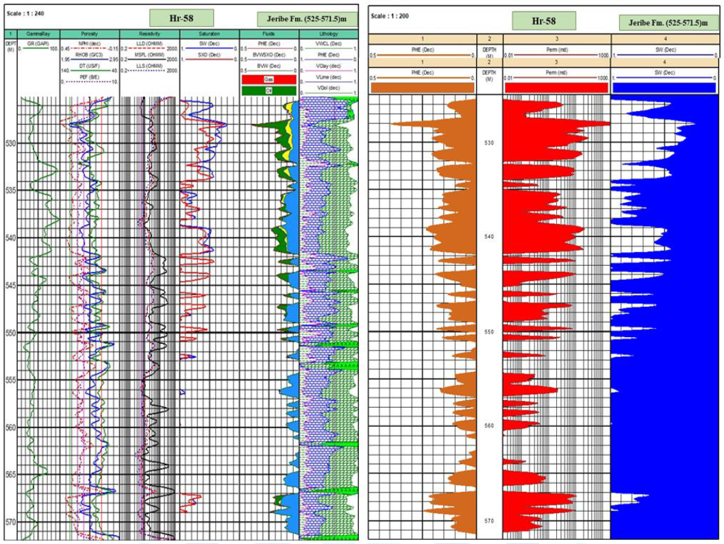
Figure3: Computer processed interpretation for Jeribe formation in Hr-58.
The production rate of Hr-54 was 160 bpd (barrels
per day), with chock size (16/64)" and very low differential pressure
(Δp=2 psi), while the production rate of Hr-56 was 400 bpd (chock size
32/64)" with high differential pressure (Δp=160 psi) that refer to a very
good petrophysical of the well Hr-54 though It had lower production rate than
the well Hr-56. The log interpretation of the well Hr-66 that completed within
Dhiban formation divided to four main units that were matching with limestone interval that
represent the reservoir units within the formation that composed mainly of
anhydrite (Figure 9). The tertiary
reservoir stratigraphy of Hamrin oil field represented by Euphrates, Dhiban and
Jeribe formations can be subdivided to three main depositional phases according
to its petro physical properties.
Phase one starts with deposition of basal anhydrite
bed (few meters) near the close of the Oligocene basin, renewed flooding of the
basin in return to deposition of deep water marls of Serekagni
formation, whereas the transition to the Euphrates records
the progradation of Miocene aged carbonate platform over the site of the Hamrin
structure, a maximum flood (the NG10 of Sharland et al) [9] probably lies in
the basal part of Serekagni. Phase two started with the major sea level fall
that resulted in isolation of the basin and development of basinal brines, from
which Dhiban evaporates were deposited. These evaporate passes transitionally
into the lower part of Jeribe formation. Phase three represent the
re-establishment of an open marine basin across the region, and deposition of
upper part of Jeribe formation that represent a good reservoir unit in this study.
Conclusion
The Tertiary reservoir of Hamrin oil field
represented by Jeribe, Dhiban and Euphrates formations were evaluated using
well log interpretation. The log interpretation of these formations showed that
the Jeribe formation divided to two units, the upper unit had better petro
physic properties than the lower unit. Dhiban formation divided to four units
that were matching with the limestone beds that alternate with anhydrite that
represent the main lithology of this formation. Euphrates formation divided to
three thick units and one thin unit.
These petro physical units reflect generally the
deposition environment of these formations. The basal Anhydrite that remarks
the close of the Oligocene basin, overlain by interval (Serekagni-Euphrates)
that records the progradation of Miocene aged carbonate platform across the
location of the Hamrin structure after the flooding of basin in the beginning
of Miocene that refer to the depositional phase one. Phase two starts with
major sea level fall and development of brine basin resulted in deposition of
Dhiban formation and lower part of Jeribe formation. The development of a
stable shallow water platform system and deposition of the upper part of Jeribe
formation represent the phase three.
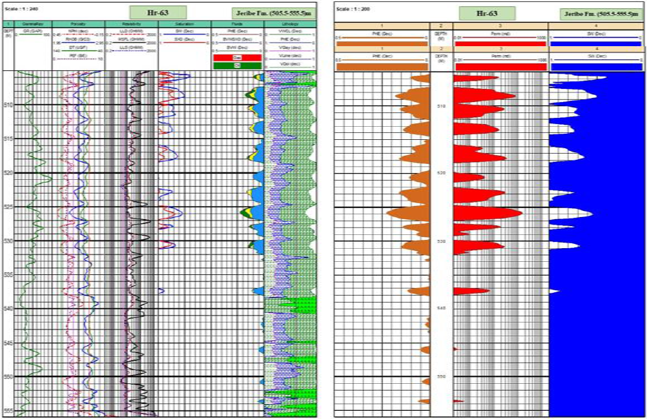
Figure 4: Computer processed interpretation for Jeribe formation in Hr-63.
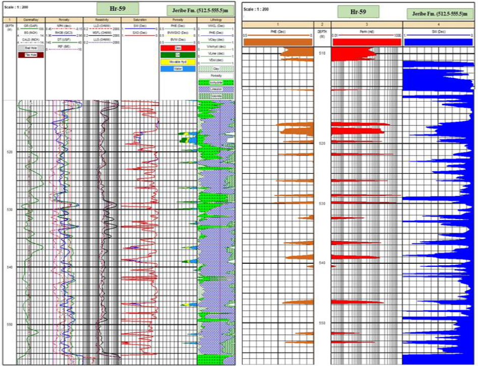
Figure 5: Computer processed interpretation for Jeribe formation in Hr-59.
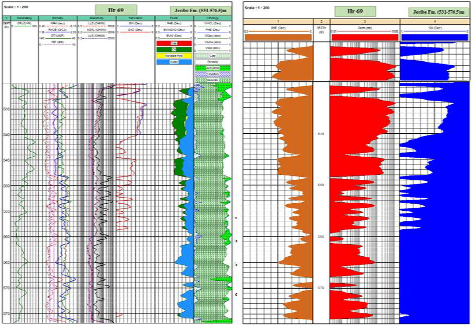
Figure6:Computer Processed Interpretation for Jeribe Formation in Hr-69
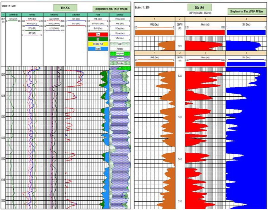
Figure7:Computer Processed Interpretation for Euphrates Formation in Hr-56.

Figure8:Computer Processed Interpretation for Euphrates Formation in Hr-54.
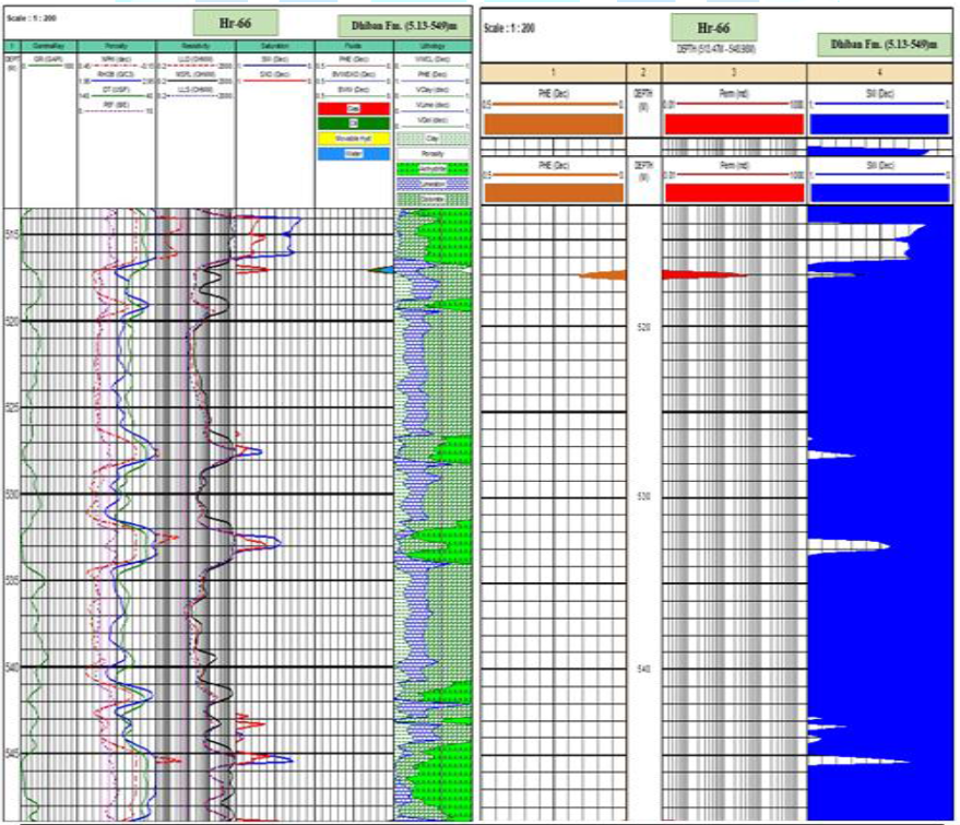
Figure9:Computer Processed Interpretation for Dhiban formation in Hr-66.